
Key Facts
Location: Franklin County
Partners: Cities of Bexley, Columbus, Dublin, Grandview Heights, Groveport, Reynoldsburg, Westerville and Whitehall, Mid-Ohio Regional Planning Commission (MORPC), Central Ohio Transit Authority (COTA), Urban Land Institute, Columbus Partnership, and The Columbus Foundation
Summary: Insight2050 Corridor Concepts provides a plan for population growth and development, over the next 30 years. Central Ohio is expected to grow by nearly one million residents by 2050; this study offers strategies for absorbing that new population.
About
Central Ohio is one of the fastest-growing regions in the United States. Estimates show that, within the next 30 years, the region will add an additional one million people. Determining where those extra 33,000 people per year will live, work, and raise their families was the goal of Insight2050 Corridor Concepts: Options for Focused Growth and Mobility Study Report.
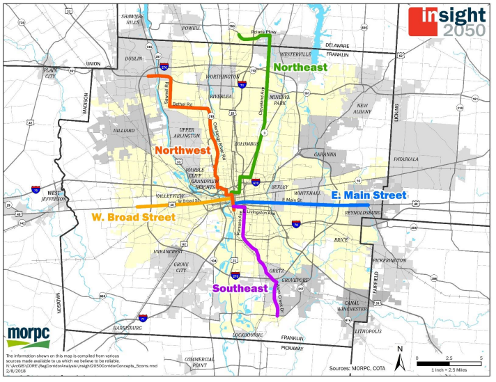
The Insight2050 Corridor Concepts study explores how more walkable, compact neighborhoods that are connected to the larger region through high-capacity transit can have a net-positive impact on transportation, infrastructure, housing, and the environment and help accommodate the projected population increase. The study focused on five existing corridors, which represent high levels of development opportunities and needs for infrastructure improvements. In addition, each of the five corridors represents existing challenges in other corridors throughout the region where success can be replicated in the future.
The five corridors in the study include:
East Broad Street: from State Route 256 to Downtown Columbus
West Broad Street: from Norton Road to Downtown Columbus
Northeast: from Polaris Parkway to Downtown Columbus
Northwest: from Post Road to Downtown Columbus
Southeast: from Rickenbacker International Airport to Downtown Columbus.
The study found that a significant amount of the population can be accommodated within the existing development footprints and focusing on transportation improvements in key corridors is a way to do that. These benefits include increasing the number of homes in close proximity to jobs; expanding residents’ transportation options by providing opportunities to walk, drive, bus, or bike; and supporting more inclusive communities for all residents within the region.
Along the examined corridors, the study also found that by focusing on development and investment along and near these existing routes, households in the region could save an average of $8,500 per year in household costs. Those savings included reduced auto and utility expenses, which is attained by a 29 percent increase per year in the number of trips people take by transit, walking, and biking. Furthermore, this increased use of alternative transportation is expected to result in a 30 percent reduction in greenhouse gas emission; and, for the region, tax revenues are projected to increase three-fold, while infrastructure costs would decrease by $10 billion.

To achieve these goals, the study recommends a number of actions that need to be taken, including:
Develop hubs of activity and infrastructure at key locations along the corridors
Dedicate right-of-way and curb space for high-capacity transit to move more people efficiently and to support a strong pedestrian and bicycle network
Apply new zoning codes and incentives to design more compact, amenity-rich neighborhoods
The study’s recommendations do not provide specifics when it comes to high-capacity transit, but they do note several possible high-capacity transit services that could exist along the corridors. Those possibilities include light rail, bus rapid transit, autonomous rapid transit, or pools of autonomous cars or smaller vehicles.
Since the release of the Insight2050 Corridor Concepts study, the City of Columbus, COTA, MORPC, and the Ohio State University committed $1 million to study ways to boost transit and denser development along the Northwest Corridor. This area of the study focused on Olentangy River Road, a winding thoroughfare that meanders along the Olentangy River between the cities of Dublin and Columbus. The study’s main goal was to see how to reserve one of the existing lanes of traffic along that roadway for a form of dedicated transit.